


The Mississippi River has many nicknames. Now it has a new one: America’s ‘most endangered river.’
April 14, 2020
CHICAGO — The upper Mississippi River, from its headwaters in Minnesota to the southern tip of Illinois, has been named the most endangered river in the United States, according to an annual list released by American Rivers, a national advocacy group.
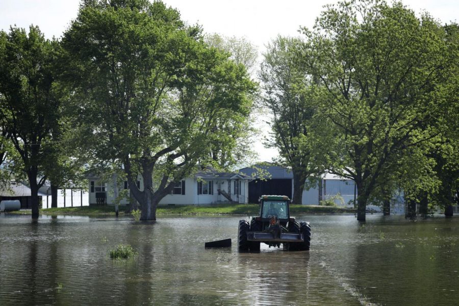
Citing record-breaking flooding in 2019, which left cities, towns, farm fields and marshlands along the river waterlogged for months, the group urged federal, state and regional leaders to work toward solutions that allow the landscape to hold more water and give the river room to flood safely.
American Rivers says development, crop drainage systems, levees, disparate flood plain management and climate change in general have made the Mississippi River less stable and more prone to flooding. The situation not only puts people at risk, the group argues, but harms fish habitats and essential ecosystems along the river.
“People are starting to understand that the flooding control systems you put in place upstream can have a profound effect downstream,” said Chris Williams, senior vice president for conservation at American Rivers.
Williams said the group debated whether to postpone the release of its annual Top 10 most endangered list during the coronavirus pandemic, but decided to move forward because climate change, flooding and the issues affecting rivers and ecosystems do not stop during a health crisis. If anything, Williams said, coronavirus may provide additional challenges for river communities if spring flooding begins to occur and stay-at-home and social distancing guidelines remain in place.
Flooding on the Mississippi River and its tributaries throughout Illinois and the Midwest caused an estimated $6.2 billion in damage across 13 states in 2019, according to the National Oceanic and Atmospheric Administration. The floods, which overwhelmed towns, farms, roads, bridges, levees and dams, contributed to the deaths of four people.
The 2019 Midwest flooding was the 51st costliest climate disaster in the U.S. since NOAA began tracking the cost of floods, hurricanes, severe storms, droughts, wildfires and winter storms in 1980.
Williams said state and federal agencies should work to develop a coordinated watershed management system that ensures that vulnerable communities are involved in decision-making that accounts for climate change and gives the river room to flood safely.
Many farmers, residents and leaders of towns on the banks of the river and those in the shipping industry argue the network of levees that lines the Mississippi protect valuable agricultural land and homes and businesses while allowing for the safe transportation of goods along the river. But groups such as American Rivers, along with many scientists, say the levees restrict the natural flow of the river, constricting its path and exacerbating flooding downstream, especially as the Midwest has experienced more frequent downpours in recent years. As floodwaters funnel southward, counties in Illinois and Missouri have been particularly deluged when the Mississippi spills over its banks.
Two other Midwestern rivers made the Top 10 list this year, including the lower Missouri River, which flows into the Mississippi north of St. Louis. American Rivers highlighted the section that flows past Nebraska, Iowa, Kansas and through Missouri, which also was plagued by flooding last year.
The other Midwestern waterway is the Menominee River, which forms the border between Wisconsin and the Upper Peninsula of Michigan. A new metallic sulfide mine is being planned near the banks of the Menominee, drawing the ire of environmentalists who argue the operations will pollute the waters, harm wildlife and threaten the area’s drinking supply.
The Menominee River also is central to the history and culture of the Menominee Indian Tribe of Wisconsin, and American Rivers contends the mine may threaten the tribe’s sacred sites.
The fate of the mine, which is proposed for the Michigan side of the river about 75 miles north of Green Bay, Wisconsin, remains up in the air. Federal litigation and permits are pending.
Dick Dragiewicz, a member of the Coalition to Save the Menominee River, said he is worried the chemicals and runoff from the mine will pollute the river all the way to where it drains into Lake Michigan.
“Lake Michigan also would be affected by the pollution. If you destroy all this, or certainly damage it, then what do you do? You don’t have a river anymore,” said Dragiewicz, who lives in Northbrook and frequently visits the river to fish for smallmouth bass with friends.
The rest of the Top 10: the Big Sunflower River in Mississippi, the Puyallup River in Washington state, the South Fork Salmon River in Idaho, Rapid Creek in South Dakota, the Okefenokee Swamp & St. Marys River in Florida and Georgia, the Ocklawaha River in Florida and the lower Youghiogheny River in Pennsylvania.
American Rivers selects its yearly list based on a river’s significance to human and natural communities, the magnitude of threats and whether there is a major public decision or policy action that will affect the waterway during the coming year.
“This is not a list of rivers that are gone,” Williams said. “It’s a list of rivers that are still with us that we have a chance to help.”